A new research by an international team of experts from the universities and scientific organizations in the UK, Germany, Russia, Kazakhstan, Azerbaijan, and Turkmenistan published in the scientific journal Communications Earth & Environment, assessed the impacts of Caspian Sea level decline on habitats, protected areas, and human infrastructure. The research revealed that a decline of 5-10 meters is expected to disrupt ecosystems, shrink protected areas, and threaten billions of dollars’ worth of infrastructure. 77,000 km2, or 20% of the Caspian’s current surface area, will turn into land, at just 5 m drop. The northern basin, Kara-Bogaz-Gol, and Turkmenistan’s shore are expected to suffer the most. Ports will be impacted in all countries, including Turkmenistan.
The current state of the Caspian Sea
The Caspian Sea spans an area of about 1150 km by 450 km, surrounded by Azerbaijan, Iran, Kazakhstan, Russia, and Turkmenistan. The current area of around 387 thousand km2 is divided into the northern Caspian basin (with an average water depth of 5 m), the middle basin (around 788 m deep), and the southern basin (more than 1000 m deep).
The Caspian Sea plays an important role in the biodiversity of Europe and Central Asia, hosting over 300 species of invertebrates (animals without a backbone), 76 species of fish, and the endangered Caspian seal, whose habitat is mainly in the northern basin. The Caspian coasts serve as a crucial stopover for many migratory birds as it is located on the major ways between Europe, Asia, and Africa.
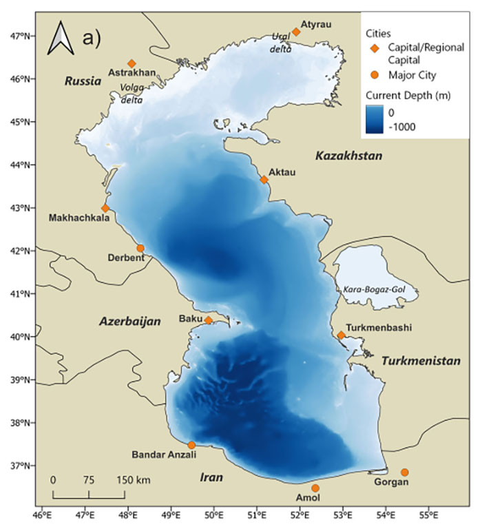
Figure 1. Depth levels of the Caspian Sea and major coastal cities.
Source: Fig.1 of Court et al. (2025).
Sea level decline in the 20-21st centuries
The Caspian Sea’s water levels have fluctuated throughout the 20th century, declining and rising again over the years. The shifts in water levels were driven by a mix of natural and human-induced factors, including river inflows, precipitation levels, and evaporation rates. However, climate change has intensified the problem since the 2000s. In 2002-2015, the Caspian Sea’s level declined by around 6 cm per year – a rate that is 20 times faster than global sea level rise. From 2020 onwards, some years have seen declines as steep as 30 cm per year.
The consequences of this decline are already visible. By the end of 2024, the northeastern coastline has receded by more than 56 km compared to 2001. Many areas previously recognized for their ecological significance have dried out and habitats lost. In the future, just a 5-10 meter drop in water level could lead to a reduction of current marine protected areas by 94%.
Modelling studies predict that the sea level may drop by around 5 m by 2100, but more up-to-date projections show that even 9-21 m decline is possible under medium and high emission scenarios. The decline would make significant impacts on the Ecologically and Biologically Significant Areas (EBSA) and Marine Protected Areas (MPA). A 5 m drop will reduce the EBSA by almost 37% and MPA by 85%, while a 15 m decline in sea levels will cause almost 90% reduction in EBSA coverage and a 100% reduction in the MPAn. Furthermore, 77,000 km2, or 20% of the Caspian’s current surface area, will turn into land, at just 5 m drop. The northern basin, Kara-Bogaz-Gol, and Turkmenistan’s shore are expected to suffer the most.
Donate to support Turkmen analysts, researchers and writers to produce factual, constructive and progressive content in their efforts to educate the public of Turkmenistan.
SUPPORT OUR WORK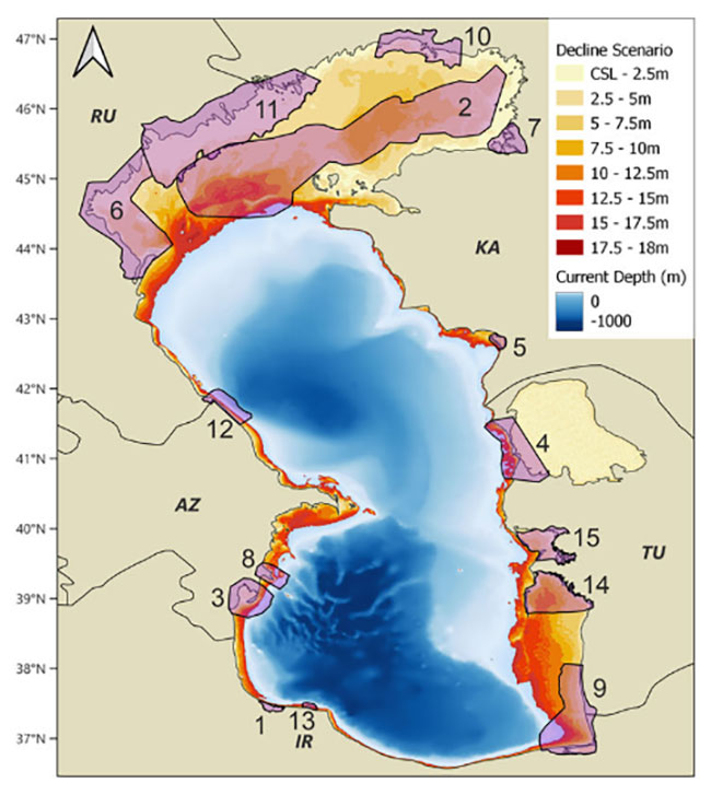
Figure 2. Caspian Sea areas affected by the decline in Sea levels in different scenarios.
Source: Fig.5 of Court et al. (2025).
Impacts on population and infrastructure in Turkmenistan
More than 15 million people live on the Caspian Sea coast and the sea level decline is already presenting major challenges. Shipping routes, fisheries, and civil and industrial infrastructure, including major ports and oil and gas production facilities, are affected.
Ports and industrial infrastructure will be affected by shoreline retreat with disruptions already at a decline of 2.5 m. Out of 22 industrial facilities (ports, refineries, gas processing plants) analysed in this study, 8 will have an increase in distance to the shoreline of more than 5 km at 10 m sea level decline. Ports will be impacted in all countries, including Turkmenistan. More specifically:
- Turkmenneftgas oil refinery, currently 1.5 km from the shore, could find itself 2.7 km (at 2.5 m sea level decline) to 17.2 km inland (at 18 m decline).
- Ports of Okarem, Hazar, and Kiyanly will experience shore retreat of 67, 23, and 7 km, respectively.
- The Turkmenbashi International Seaport may experience shore retreats at already 5 m decline in sea level, with up to 17.4 km shore retreat in the worst scenario (18 m sea level decline).
Many settlements along the shore across all countries, including Turkmenistan, will find themselves further away from the shore. These include:
- Bekdash: the distance to the shore will change from 2.11 km today to 3.1 m (under a 18 m decline scenario).
- Karshy: the distance will change from 0.59 km to 0.9 km (under a 2.5 m decline) and 4.71 km (under a 18 m decline).
- Hazar: the position will change from being right at the shore to up to 12 km away from the shore, if the sea level declines by 18 m.
- Esenguly: distance to the shore may change from 7.6 km to 49 km.
- Turkmenbashi: the current distance of 2.42 km may increase to 17.35 km.
Apart from the threats to the infrastructure, dried up sea bed will expose the population to toxic dust and pollutants, causing respiratory issues, similar to the environmental disaster that happened with the Aral Sea. Furthermore, land degradation will be worsened, making these newly dried lands unusable for agriculture.
The Caspian Sea’s rapid decline already threatens regional ecosystems, the winter breeding habitats of Caspian seals, and the regional climate stability. Without action, the social and economic consequences will only worsen, with critical infrastructure stranded far from the waterline and local populations exposed to environmental hazards.
The authors are calling for a more dynamic and adaptive approach to conservation planning. Protected areas need to account for rapidly changing sea levels, and pre-emptive measures must be taken to protect the habitats and infrastructure. Adaptive planning is needed to mitigate the impacts of human activities, especially if relocation of infrastructure such as ports or shipping routes will be needed.