A new textbook titled “Seismic Risk” by S. Tyagunov was published on January 21, 2025. Sergey Tyagunov is an international consultant on Seismic Vulnerability and Seismic Risk at UNDP. The textbook preparation is part of the UNDP project “Strengthening National Capacity for Seismic Risk Assessment, Prevention and Response to Potential Earthquakes”.
The project was initially reported as completed in December 2024, but a recent update on the project website shows that it has been extended to June 2025 with an estimated budget of $103,306 for 2025. The project has been highlighted by Progres.Online in a recent article for a lack of public’s access to the project’s impact.
Our research shows that this textbook might be the only resource on this topic that has been published in cooperation with international experts in the last 30 years in Turkmenistan.
The textbook is intended for higher educational institutions, particularly for civil engineering and other engineering students, mainly pursuing Master’s degrees in Turkmenistan. It provides an introduction to seismic risk assessment, and may also be useful for specialists involved in earthquake safety and disaster response. The textbook covers general knowledge about tectonic plates and earthquakes, with some focus on seismic activity in Turkmenistan.
The textbook is written in Russian, no translations to English or Turkmen are available.
Turkmenistan is one of the most seismically active regions in Central Asia and worldwide, due to the collision of the Arabian and Eurasian tectonic plates. The Institute of Seismology and Atmospheric Physics of the Academy of Sciences of Turkmenistan records up to 6,000 seismic events annually on the territory of Turkmenistan. Although most of them are low magnitude events, there are no warnings in the media or public announcements from the government officials on even more serious events.
The most destructive earthquake in the country’s history was the Ashgabat earthquake on October 6,1948, with a magnitude of 7.3, one of the deadliest seismic events in the world.
Seismologists have identified four high-risk regions in Turkmenistan: Turkmen-Khorasan, Balkhan-Caspian, Elburz and Gaurdak-Kugitang. A seismic zoning map, shown in Figure 1, was developed to show different levels of seismic risks and the expected frequency of seismic events. The map is used to guide construction and urban planning in high-risk areas.
Donate to support Turkmen analysts, researchers and writers to produce factual, constructive and progressive content in their efforts to educate the public of Turkmenistan.
SUPPORT OUR WORK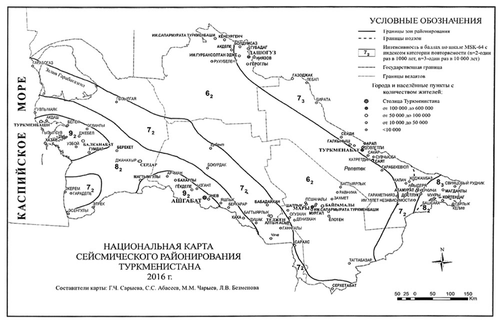
Figure 1. Map of seismic zoning of Turkmenistan. Source: Tyagunov, Textbook on Seismic Risk.
Building types and their vulnerability
The national building code of Turkmenistan classifies buildings into 9 categories based on the material of the supporting structures of buildings. The first three types of buildings (category 1, 2, 3) are constructed without considering seismic risks or seismic design, making them particularly vulnerable and at higher risks during earthquakes. The remaining 6 types (categories 4-9) are assessed based on varying levels of anti-seismic measures, corresponding to seismic intensities of 7, 8, and 9.
The book also presents findings from a seismic risk assessment conducted for Ashgabat. Data from 8267 building passports showed that most of the housing stock in the city falls under type 3, with the remaining buildings classified as type 4-8. However, when population density is considered, the majority of people live in buildings of type 4, 5, 7, and 8, which are built with seismic design in mind.
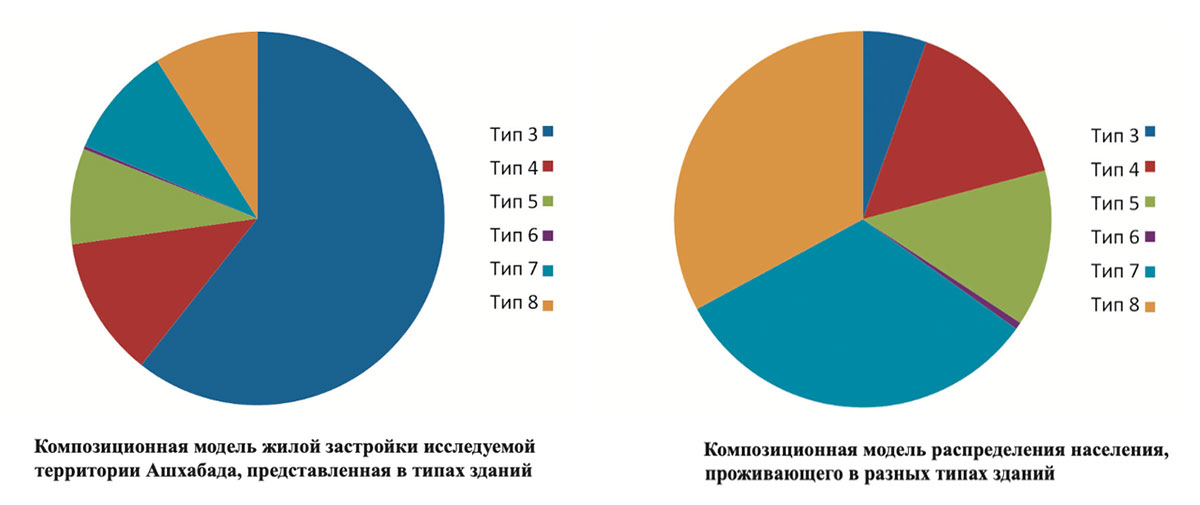
Figure 2. Composition of the housing stock in Ashgabat based on the number of buildings (left) and recalculated for population density (right). Source: Tyagunov, Textbook on Seismic Risk. The details on what kinds of buildings constitute each category are available in the Textbook Table 3.6.
The results of the building stock analysis have contributed to a development of a map of potential damages to building stock in case of seismic events, shown for Ashgabat in Figure 3.
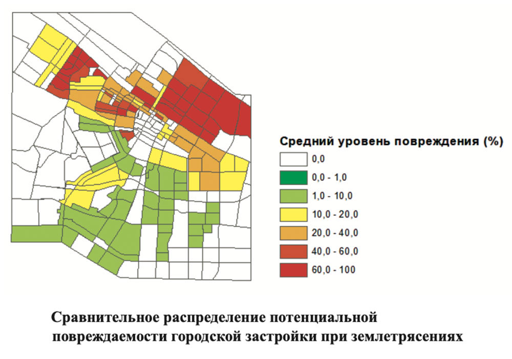
Figure 3. Risk of damages for different parts of Ashgabat.
The textbook serves as a valuable resource for improving seismic risk assessment and earthquake preparedness in Turkmenistan and beyond. Together with the English-Russian-Turkmen Dictionary of Geological, Seismological and Geophysical terms, also published in January 2025 as part of the project, it may support the government and specialists to assess, analyze, and mitigate risks caused by earthquakes.
Given the inevitability of seismic events and the lack of human control over them, it is essential to recognize seismic risks and consider them as an essential part of urban development and long-term planning. Thus, the government and research institutions must perform region-specific quantitative assessment of seismic risks so more targeted mitigation strategies can be adopted. Furthermore, “acceptable” levels of risks are not universal and region- or even building-dependent, with government officials responsible for determining the acceptable level, depending also on the financial resources available to mitigate potential risks. Finally, the textbook recommends performing an economic analysis of potential losses (“optimality criterion”) together with the “safety criterion”, or acceptable levels of risk to human life and environment. Considering these factors will help to optimize the development of anti-seismic measures.