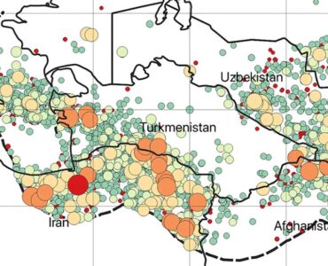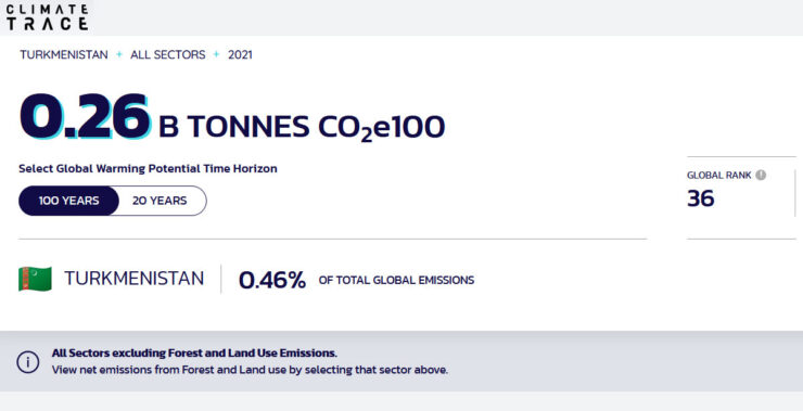
According to Climate TRACE, Turkmenistan emitted a total of 448 million tons of carbon dioxide in 2021. The database has emissions data from 51 physical assets. Climate TRACE uses a comprehensive map to display carbon dioxide emissions of countries all over the world. The South Caspian Basin oil and gas field is ranked number one in the country and 21 globally in terms of emissions. The South Caspian Basin with emissions of 33.51 MT and Amudarya Basin with emissions of 25.02 MT rank one and two in Central Asia with Karachaganak in Kazakhstan being number 3 (14.53 MT).
- South Caspian Basin: 33.51 MT (million tons of Carbon Dioxide emitted in the past 20 years), Rank 1;
- Amudarya Basin: 25.02 MT, Rank 2;
- Makhtumkuli: 9.92 MT, Rank 3;
- Samandepe: 9.24 MT, Rank 4;
- Mary Power Station: 7.29, Rank 5;
- Dzheitune: 4.34 MT, Rank 6.
Climate TRACE is a global non-profit coalition that has been independently tracking greenhouse gas emissions since July of 2020. Greenhouse gasses are gasses (mainly carbon dioxide) that are emitted into the atmosphere as a result of human activities on earth, including the burning of fossil fuels such as coal, oil, and natural gas. Their emission greatly contributes to climate change. More than 100 organizations are involved in this initiative, including Blue Sky Analytics, Carbon Yield, Johns Hopkins University Applied Physics Laboratory, and even former U.S. Vice President Al Gore. Climate TRACE calculates emissions by analyzing more than 59 trillion bytes of data collected from over 300 satellites in addition to using the latest research on emitting sectors.